See a listing in Waves labeled “semi‑oceanfront” and wonder what it really means for beach access, views, and value? You are not alone. On Hatteras Island, words matter because sand and shorelines move. In a few minutes, you will learn what semi‑oceanfront typically means in Waves, which rules and maps to check, and how that affects insurance, rentals, and risk. You will also get a simple checklist to verify any listing before you make an offer. Let’s dive in.
What semi‑oceanfront means in Waves
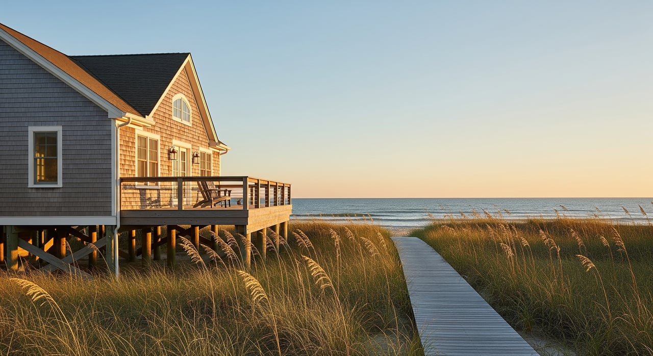
“Semi‑oceanfront” is a marketing description, not a legal term in North Carolina or Dare County. It is used to signal that a property is very close to the beach, may have partial or seasonal ocean views, and usually offers a short walk to the sand. Because it is not defined by law or zoning, you should treat it as descriptive language, not a guarantee of frontage, view, or protected access.
In Waves, you will commonly see three situations:
- A lot on the ocean side of NC‑12 but set behind dunes, a public easement, or a small street. These often have partial or seasonal views and a short walk to the beach.
- A lot one row behind true oceanfront homes. It is close to the water but does not directly touch the dune line. Upper levels may have sight lines to the ocean.
- An elevated lot inland of the primary dune, where upper floors capture ocean views even if the ground level does not.
It helps to distinguish semi‑oceanfront from similar terms:
- Oceanfront or beachfront means the lot directly adjoins the beach or dune line with immediate, unfettered access.
- Ocean‑view or partial ocean view focuses on the view, not proximity.
- Ocean side of NC‑12 is a geographic cue. It often overlaps with semi‑oceanfront in Waves but is not the same as frontage.
How the island setting affects it
Dynamic shoreline and dunes
Waves sits on Hatteras Island, a barrier island shaped by wind, waves, and storms. Shoreline positions have shifted over time and can change quickly during major events. If you want parcel‑level history for a specific area, review the North Carolina Division of Coastal Management’s Shoreline Change maps and data. The NC Division of Coastal Management Shoreline Change Project is a helpful starting point.
Public beach and park context
Much of the island’s beachfront touches or sits near Cape Hatteras National Seashore. The National Park Service oversees public access points and parking in certain areas. That can improve convenience for a semi‑oceanfront home, but private lots still have private property lines behind the primary dune. You can learn more about access areas and park management on the Cape Hatteras National Seashore site.
Setbacks, permits, and dune protection
Coastal property is governed by North Carolina’s Coastal Area Management Act. Many construction and shoreline activities require permits, and dune systems are protected. These rules can limit what you may do to create direct access paths or alter dunes to improve views. Review the CAMA overview and talk with local officials before planning changes.
Flood zones and elevation
Many properties in Waves lie within FEMA Special Flood Hazard Areas. If you use a federally regulated lender and the structure is in a mapped hazard zone, flood insurance is usually required. Premiums often depend on the structure’s elevation relative to the Base Flood Elevation and other risk factors. Check zones for a specific parcel through the FEMA Flood Map Service Center. An Elevation Certificate is commonly needed for underwriting and pricing.
Road realities on NC‑12
NC‑12 is the primary road through Hatteras Island. Even if your home is a short walk to the ocean, island access can be disrupted by overwash or storm damage. This is part of the practical risk profile for any oceanside location in Waves.
Value, rentals, and risk
Semi‑oceanfront typically sits in a middle ground on price. You often see a premium over more inland or soundside homes, but not as high as true oceanfront. The exact premium depends on view quality, distance and walkability to the beach, elevation, and rental performance.
For renters, proximity to the beach without full oceanfront pricing can be appealing. If you plan to market the home for short‑term rentals, be clear in your listing about the walk to the beach and the view from each level. Clear expectations protect guest satisfaction and repeat bookings.
Risk is still real. Being behind a dune or one street back does not remove exposure to storm surge, floodwater, wind, or long‑term shoreline change. The island’s sandy soils, septic systems, and salt air also add to maintenance considerations. Your decision should balance lifestyle and rental goals with a realistic view of risk and upkeep.
Insurance, lending, and permits
Here is what to expect as you plan a purchase:
- Flood insurance. If the home is in a FEMA Special Flood Hazard Area and you use a conventional lender, flood insurance will likely be required. An Elevation Certificate helps insurers price the risk.
- Documentation. Lenders may ask for surveys, elevation data, and proof that improvements meet coastal construction standards.
- Permitting. Many shoreline or dune activities require coastal permits under CAMA. Always confirm what is allowed before budgeting for access paths, decks, or grading.
What to verify for any semi‑oceanfront listing
Use this checklist to confirm what you are actually getting:
- Property survey or plat. Confirm boundaries, setbacks, and any easements. Ask the seller for the most recent survey and look for recorded access strips.
- Dare County records. Use the county’s site to find GIS maps, assessor records, and contacts for Planning and Inspections. Start at the Dare County Government site.
- Flood zone and BFE. Check your parcel’s zone and Base Flood Elevation using the FEMA Flood Map Service Center, then request an Elevation Certificate to estimate insurance costs.
- Shoreline trends. Review historical shoreline movement and erosion patterns near your area in the NC Division of Coastal Management Shoreline Change Project.
- Long‑term inundation. For a high‑level look at future sea level scenarios, use the NOAA Sea Level Rise Viewer.
- Park and access context. If you rely on public access, check nearby parking and path locations through the Cape Hatteras National Seashore.
Questions to ask the seller or listing agent
- What is the measured distance from the structure to the mean high water line or to the toe of the primary dune?
- Which FEMA flood zone applies to the structure and the lot? Is there a current Elevation Certificate?
- Where is the nearest public beach access, and does it include parking?
- Are there any recorded easements or restrictions that affect views or access?
- What is the history of storm damage, insurance claims, or dune maintenance near the property?
- Is the property subject to any HOA rules or rental restrictions?
Work with the right local pros
A good team helps you move from questions to confidence. Consider engaging:
- A licensed land surveyor for boundary verification, setback lines, and an Elevation Certificate.
- A local coastal or civil engineer if you have concerns about erosion, dune stability, or access design.
- A coastal insurance broker who knows NFIP and private flood markets on the Outer Banks.
- A local real estate agent with Waves and Hatteras experience, who understands rental demand and island logistics.
- Dare County Planning, Inspections, and the Health Department for permitability, septic, and construction standards.
Next steps
Semi‑oceanfront in Waves can deliver a close‑to‑the‑sand experience with a balanced price point compared to oceanfront. The key is to verify distance, access, elevation, and flood data before you buy. If you want a second home, a strong rental, or a place for long beach weeks, we can help you trace the details and make a confident choice.
If you are ready to explore current options or want a quick read on a specific address, reach out to OBX Beach Properties. We will walk you through maps, permits, and risk checks so you can move forward with clarity.
FAQs
How far is “semi‑oceanfront” in Waves?
- There is no standard distance. In Waves it often means a lot on the ocean side of NC‑12 or one row behind the dune or street. Verify with a survey and parcel map.
Is beach access guaranteed for semi‑oceanfront homes?
- Not automatically. Access depends on public access points or recorded easements. Confirm the nearest public path and any easements in the property’s records.
Do semi‑oceanfront homes require flood insurance in Waves?
- If the structure is in a FEMA Special Flood Hazard Area and you use a regulated lender, flood insurance is usually required. Check the FEMA map and get an Elevation Certificate.
Are semi‑oceanfront homes safer than oceanfront during storms?
- They can be less exposed to direct wave action, but still face flood, wind, and overwash risks. Evaluate each parcel’s elevation, dune setting, and flood zone.
Is semi‑oceanfront a good rental investment on Hatteras Island?
- Many renters like the proximity without full oceanfront pricing. Success depends on actual access, view quality, rental rules, insurance costs, and ongoing coastal risk.
